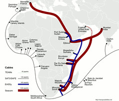
 In the spirit of the previous post consolidating information on African undersea cables, I compiled the image at the right to create a consolidated picture of existing and future cable initiatives around the continent. The relative cable sizes are roughly to scale according to the advertised capacity of the cables. There is certainly a contrast between the various initiatives.
Notable absences here are the Uhurunet and Infraco initiatives, not to mention Flag’s Next-Generation-Network or Main One. If anyone has maps of proposed routes for these initiatives, I would love to hear about it. I also have this map in an SVG file in which all the elements are scalable vector graphics, ideal for editing or adding to. You’ll have to post a comment or email me to ask for though as there appears to be a bug in the file uploading on the blog.
Note: the most up-to-date version of this map can be found at http://manypossibilities.net/african-undersea-cables.
Pingback: Telecommunication « Helen King